Welcome |        Education   |   Job Training    |   Home Town       |    Favorite Links     |   TrackStar  |   WebQuest
Web-Based Lesson      |   Lesson Plan    |    Contact Me
Visiting to Indonesia

A WebQuest for 9-12 Grade (Social Science)

Designed by   :
Abdul Rajak Husain

 
Send email, click here!

Indonesian Flag

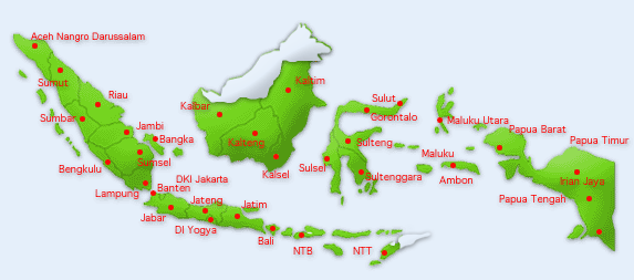
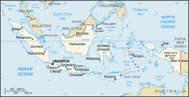
Map of Indonesia

Indonesian Coat of Arms


IntroductionTask Standards | Process | Evaluation | Conclusion | CreditsStudent Page

 
Introduction

The idea for this lesson comes from the fact that many people in the world know more about Bali rather than Indonesia. Even some of them think that Indonesia is a part of Bali. To dismiss and reduce this misinformation, this lesson will give clear explanations, sources, facts, maps, history, geography, people, places, and other related information about Indonesia and Bali. So, students and other people will know that Bali is just a small island in Indonesia. It is also a name of province in Indonesia.

By visiting many sites of Indonesia and Bali, students and people in the will have better understanding and clear infomation about Indonesia and Bali.
 

Learners

This WebQuest is designed for 9-12, especially for Social Science. In this lesson students will learn about geography, history, cultures, government, tourisms, people or population, and other related information and facts about Indonesia, including Bali.

It is supported by Louisiana Content Standards for 9-12 grades, such as extending and refining their knowledge including the World in Spatial Terms, Places and Regions, Physical and Human Systems, and Environment and Society.


Curriculum  Standards

This lesson is based on the Louisiana Content Standards, as follows:
 

BENCHMARKS 9-12 

As students in Grades 9-12 extend and refine their knowledge, what they know and are able to do includes: 

A. The World in Spatial Terms 

  • G-1A-H1 using geographic representations, tools, and technologies to explain, analyze, and solve geographic problems; (1, 2, 3, 4) 
  • G-1A-H2 organizing geographic information and answering complex questions by formulating mental maps of places and regions; (1, 2, 3, 4) 
    • B. Places and Regions 
       
      • G-1B-H1 determining how location and social, cultural, and economic processes affect the features and significance of places; (1, 2, 3, 4) 
      • G-1B-H2 analyzing the ways in which physical and human characteristics of places and regions have affected historic events; (1, 2, 3, 4) 
      • G-1B-H3 analyzing the various ways in which physical and human regions are structured and interconnected; (1, 2, 3, 4) 
      • G-1B-H4 explaining and evaluating the importance of places and regions to cultural identity; (1, 2, 3, 4, 5) 


      C. Physical and Human Systems 
       

      • G-1C-H1 analyzing the ways in which Earth’s dynamic and interactive physical processes affect different regions of the world; (1, 2, 3, 4) 
      • G-1C-H2 determining the economic, political, and social factors that contribute to human migration and settlement patterns and evaluating their impact on physical and human systems; (1, 2, 3, 4) 
      • G-1C-H3 analyzing trends in world population numbers and patterns and predicting their consequences; (1, 2, 3, 4) 
      • G-1C-H4 analyzing the characteristics, distribution, and interrelationships of the world’s cultures; (1, 2, 3, 4, 5) 
      • G-1C-H5 describing and evaluating spatial distribution of economic systems and how economic systems affect regions; (1, 3) 
      • G-1C-H6 analyzing how cooperation, conflict, and self-interests impact social, political, and economic entities on Earth; (1, 2, 3, 4, 5) 


      D. Environment and Society 
       

      • G-1D-H1 describing and evaluating the ways in which technology has expanded the human capability to modify the physical environment; (1, 2, 3, 4, 5) 
      • G-1D-H2 examining the challenges placed on human systems by the physical environment and formulating strategies to deal with these challenges; (1, 2, 3, 4, 5) 
      • G-1D-H3 analyzing the relationship between natural resources and the exploration, colonization, settlement, and uses of land in different regions of the world; (1, 2, 3, 4, 5) 
      • G-1D-H4evaluating policies and programs related to the use of natural resources; (1, 2, 3, 4, 5) 
      • G-1D-H5 developing plans to solve local and regional geographic problems related to contemporary issues. (1, 2, 3, 4, 5) 


    The Process
  • Each group will visit some sites to get the information that you are looking for. Each group has its own project. However, you can support and help each other.
  • You can share information that you find to your friends in other groups.
  • Now, it is time to start your project.
  • Search and visit some sites that you think are properly for your project. Remember, you have to make a note for the useful information you get.

  • Here are the sites you may visit.


    Map of Indonesia

    Geography of Indonesia
    1. Click the map of Indonesia, then find the names of islands and and cities that you can see in the map. 
    2. Find the information about Indonesian geography here. Remember, you have to make a note for the useful information you get, such as the total number of islands in Indonesia, major islands, the location of Indonesian territory on the latitude and longitude, and provinces. To get more information about Indonesian provinces, you can visit other sites, such as Mindspring, Insan Web, the World-Gazetteer, Country and Regions

    Indonesian People 

    Indonesian People
    1. Search and visit some sites, such as the World Factbook 2002 by CIA, Deplu, Indonesian Embassy (Addis Ababa, Ethiopia), Overview of Indonesia, Tourism Indonesia, Jakarta-Dhaka, and Infoplease
    2. Make a note about some information related to Indonesian people, such as the total number population in 2002, tribes or ethnic groups, languages, religions, cultures, and their traditions.

    Indonesian soldier (Heiho) in Japanese 

    Colonial Era

    Indonesian History
    1. Go to some sites about Indonesia history, such as Embassy of Indonesia for Canada, Line of Indonesia, Network of Indonesia, Info Indo, and the History of Indonesia.  
    2. Write some information about Indonesian history. Make sure that you write only the information that you think is very important, such as the Independence Day, Colonial Era, and the periods of Indonesian history.

    Indonesian Coat of Arms

    Indonesian Government
    1. Find some information about Indonesia government. You can search and visit some sites, such as Factbook 2002 by CIA, New Government, Country Report, and Indonesian Government 2000
    2. Make a brief summary about the information you get. Make sure that you write about the country name, government type, the capital of the country, adminstrative devisions (provinces), independence day, the constitution, national anthem, and the president.

    Toraja Houses

    Visiting to Indonesia
    1. Find some interesting places in Indonesia, such as in Bali, Java, Lombok, Sulawesi, and Sumatra.
    2. Find some information about interesting places to visit and accomodation (hotels), in certain cities or areas, like Jakarta, Minangkabau, Lombok, Bali, Malang, Manado, Gorontalo & Togian Islands, and others
    3. Make a short summary about the places you have visited.
     

    Evaluation

    Each member of group will be given an individual grade (25 %), a participation grade (25 %), and a project grade (50 %) which will be added together to a comprise a major test grade (100 %).

    Aspects of Evaluation
    Beginning 
    1
    Developing
    2
    Accomplish
    3
    Score
    Coperation/ Participation The student has minimal input in group effort and activities. The student works well with other in the group effort and activities. The student organizes and contributes full to the group effort and activities.  
    Content The group provides  certain information in the project, but it is unclear and incomplete. The group provides useful information about the project: clear, brief, and complete, but still needs any supporting details. The group provides very clear, brief, complete, and useful information with some supporting details.  
    Format The group creates a simple and minimal format for the final draft, having numerous spelling and gramatical errors. The group creates a good format for the final draft, having a few spelling and gramatical errors. The group creates a complete final draft with supporting detail, having a little errors on spelling and grammar.  
    Presentation The group just reads the their final project, no supporting details. The group presents their final project in front of the class, with some difficulties in giving supporting details. The group presents their final project using powerpoint in front of the class with fewer difficulties in giving supporting details.  
    Final Draft (Summary) The group writes a final draft using a word processor contains minimal information regarding sites to be visited. The group writes a final draft using a word processor contains useful information regarding the sites to be visited. The group writes a final draft with word processor and powerpoint for presentation, contains useful and complete information with some details regarding the sites to be visited.
     
    Total grades:                                      /15 
     

    Conclusion

    Congratulation! You have successfully done your project. You have provided useful information about Indonesia. Now, many people in the world will know about Indonesia. You gave them a lot of information about Indonesian country, such as the geography, areas, islands, provinces, history, government, some interesting places, languages, ethnic groups or tribes, and the population.

    Credits & References

    I would like to thank the following people, groups, organizations as the resources for this project.

    UP

     
    My Website
    TrackStar
    Web-Based Lesson
    Lesson Plan
    @ Copyright 2002

    Abdul Rajak Husain

    Updated: December 4, 2002